Learning how to use a lensatic compass isn’t that hard. You do need to know something about its basic components though.
Basic Components
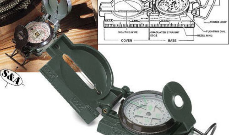
There are three parts here: the cover, lens and the base. The cover shows the wiring and points used in navigation. It also acts as a protective shield. The base contains the inner workings of the device. The main feature is the dial that shows the compass. The lens on the other hand, has the floating dial. These are only general features of course. Some have more features, but these are present in all. Now that you know its facets, you can learn how to use a lensatic compass.
Bearing
Open the device so the compass card is set at 90 degrees. Lift the lens to an angle of 45 degrees. To make it easier to manage, set the thumb on the hook. Check to make that the hook is set down before taking this step.
After setting the hook, choose the target. Modify the wiring so it aligns with the target’s center. Next, read the compass card. Adjust the lens if needed. You can read it in MILS or degrees. Do not take your eyes away from the goal.
Setting the Bearing
You need to start this by setting up the device as mentioned earlier. Now check the bezel line and make sure it’s at north. To use a lensatic compass set the direction right on north. After the arrow and bezel are aligned, the direction is now set. The sighting wire is now set. Just follow the directions.
Following the Directions
First you have to choose a landmark. This will be the indicator point. This is only for setup purposes though. Even if it disappears, the device can pinpoint you to the right location. You can even use it to create a new reference landmark.
Resection
Resection is when you use the device to establish your location. To use this feature you must have a map of the place. Look for some landmarks like trees or monuments. To use a lensatic compass, mark the azimuth from your location to the chosen landmark. Note that the rear part of this is the orientation opposite you.
Just minus 180 degrees from this measurement. Repeat the process for the other point. Get the map and set lines along the features / reference markers you have made. Illustrate lines on the azimuth angle. The points will eventually meet. That is your location.
Tips and Warnings
Some of these devices are very complex. Take the time to study its features. Do not go out and rely on it for directions if you are still studying it. It is a great navigation tool, but you should know its functions first. Probably the biggest challenge will be reading the military units, but in due time you’ll get used to it.
This device is very popular with the military. But it can also be utilized by laymen for a variety of purposes. By learning to use a lensatic compass, you can get it to serve you well.


My lensatic compass has some features that seem to turn a precision instrument into a rough tool.
The backsight is 1/16″ wide, so there is up to 1.5 degrees uncertainty in the bearing of an object. Surely a V-shape would be better?
There are two lubber lines, a short one and a long one at 315 degrees (if the short one is set to North). What is the long one for? There is no mention of the long line in the printed instructions.
The lines are 2 degrees wide so it is hard to get a bearing better than 2 degrees.
Am I expecting too much from a hand-held instrument? I have flown an aircraft across 600 miles of the Great Sandy Desert of Australia using a magnetic compass as a Primary Navigation Instrument. It was not much bigger than my lensatic compass, but being Aviation it would cost a lot more.
Chris Carter